

Faro
This page is a new addition for 2008 and features a collection of some of the places of interest you can find in and around the area of Praia da Luz. As I develop the page I will include anywhere further afield, but within a 'reasonable' drive of Luz, that I think are worth a look. There are a few more pictures to be had on my Algarve Photographs page.
Also see the Things to do page, you may be able to combine a trip.
Any remarks included here are my own views, unless otherwise credited. So please let me know if you disagree or have any of your own you think I should include. Also, If you have found any of the contents of these pages useful please tell me so I can identify the areas to develop further. Thanks and Enjoy.
08/2008 As a bit of an experiment I've just added ( to the map ) travel directions to the sights from the centre of Luz. A Google driving directions map will open ( in a new window ) on selection.
Map of Places of Interest
Click on the letter for the map location or the name for the details |
| Buildings | Ruins | Views | Other | Churches |
Bensafrim
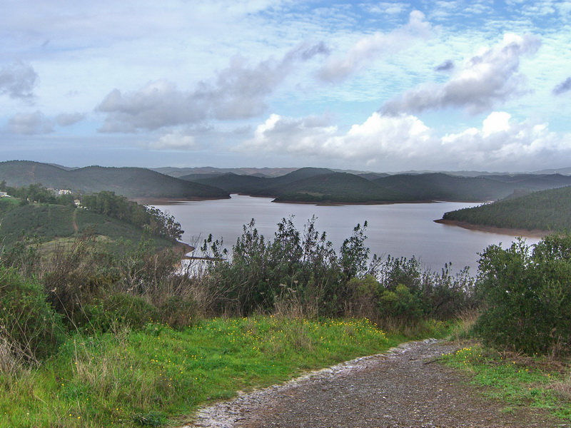 Bensafrim - The Reservoir
Not strictly Bensafrim but it seems to be the nearest town, even though it is some 10 / 15 minutes away. A bit of a
difficult place to find. Road EN125-9 is the best I have at the moment, as I wasn't really following where I was going when I stumbled on this. I'll get more details next time. A fabulous view and
some excellent walking to be had around the waterside. Probably the largest expanse of inland water in the Algarve.
Bordeira
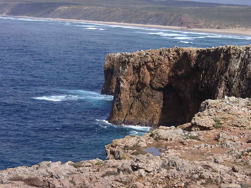 Bordeira - Atlantic Coast Views
The West coast is a complete contrast to the Algarve proper. The land is empty, bar a few villages, no
development here as it is part of the National Park. Hills, valleys and forests abound. The Atlantic is wild in comparison to the more tranquil waters 'around the corner' and is a paradise for
surfers. The cliff top at Bordeira is a perfect spot to see the awesome cliffs and long stretches of virtually empty beaches that run all the way up the coast. A truly unforgettable experience.
If viewing on the map above, switch to the satellite view and zoom in to more fully appreciate the sight.
Lagos - Lacobriga - Zawala
 Ponta da Piedade - Rock Formations
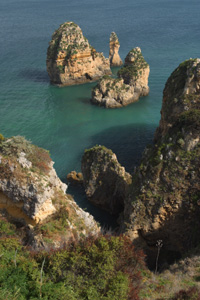
The "Bridge of Piety" probably the Algarve's most visited rock formation, with a series of really impressive
rock formations, arches, stacks and grottoes. Fishing boats depart from the Forte da Ponte da Bandeira ( the small fort on the corner of the Lagos seafront ) for the short trip west. You can also drive
to the headland. Use the car park next to the lighthouse and walk down a series of really steep steps to the the sandy coves of Praia de Dona Ana and Praia do Camilo. where there are boats that will ferry you around
for a fee. If viewing on the map above, switch to the satellite view and zoom in to more fully appreciate the actual location.
 The Slave market
Where slaves brought back from Africa during the 15th century were sold. ( It is the opposite side of Praca D.Henrique from the Misericordia Church.
Now an art gallery.
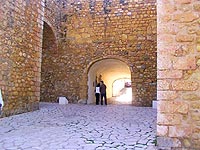 Castelo dos Governadores - Governors' Gate
The Castle of the Governors, originally built by the Arabs, has very little of its original construction remaining. Its been re-built and re-styled many times over the years. It is, however,
considered one of the main features of the city of Lagos.
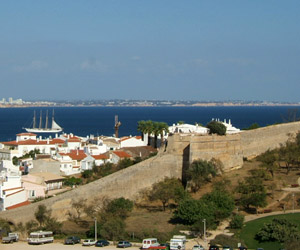 The city walls
Still surround quite a bit of the older part of the town
are really quite impressive. The foundations date from Roman times, and were strengthened during Arab and Christian occupations. Restored in the 16th century, with the best preserved section encasing a Manueline window from which Dom Sebastiao ( who raised Lagos to the status of a city in 1578 ) is said to have addressed townsfolk before going to Alccer-Quibir in North Africa, on a campaign against the Moors, from which he never returned.
( Also look out for the rather controversial sculpture of Dom Sebastiao in the main square in front of the Town Hall ). There are gateways through at various points The best way to see them is to walk around the
outside - there are landscaped gardens and paths to enjoy while you walk.
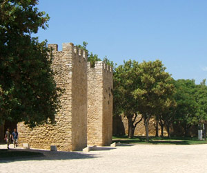 the twin watchtowers
Either side of St. Goncalo's gate ( Opposite the fort
on the water front just along from the Governor's gate ). The walls date from the 16th century and have bulwarks at intervals that allowed the use of artillery.
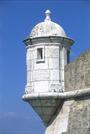 Fortaleza da Ponta da Bandeira
A 17th-century fortress, complete with drawbridge, was built to defend the harbour. Nowadays it is a small museum ( dedicated to the Age of Discoveries ).
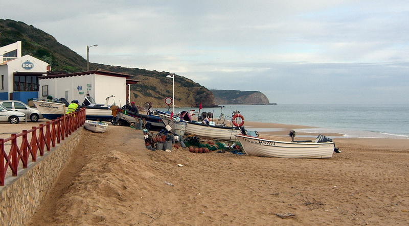
Praia da Luz
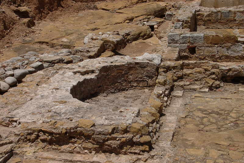 Praia da Luz - Roman Ruins - ( Ruinas Roman )
There are roman ruins, halfway along the Av. dos Pescadores. A small entrance in the wall leads you up some stairs to what remains of some fairly recently excavated Roman fish salting tanks
and a small bath complex. Regrettably only a small section now remains but is is still worth a look.
Open: Free entry to the public from 10.00 to 17.00 daily.
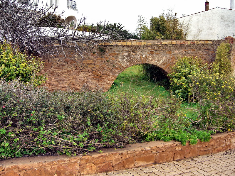 Praia da Luz - Roman Aqueduct
A small Roman Aqueduct.
Unsigned and not particularly rated as a tourist attraction as it has been heavily restored and there are better examples to be seen in the Algarve.
Where: Easily missed. Halfway down the Rua do Poco on the left.
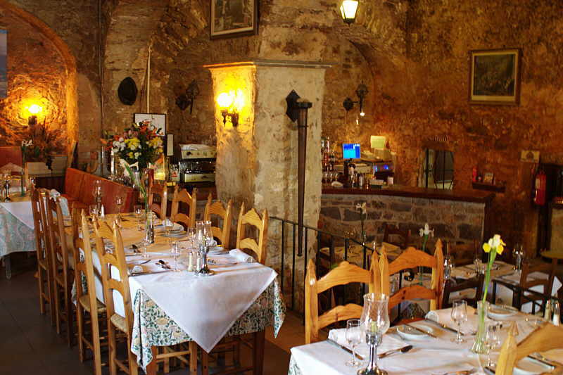 Praia da Luz - Fort - ( Fort )
Located at the west point of Luz bay is a 16th century fort. Originally built to defend against pirates. Set in lovely gardens the location offers spectacular views across the bay. It is now a
smart restaurant with a traditional dining room, an enclosed terraced dining area and outside jazz barbeques in the summer months.
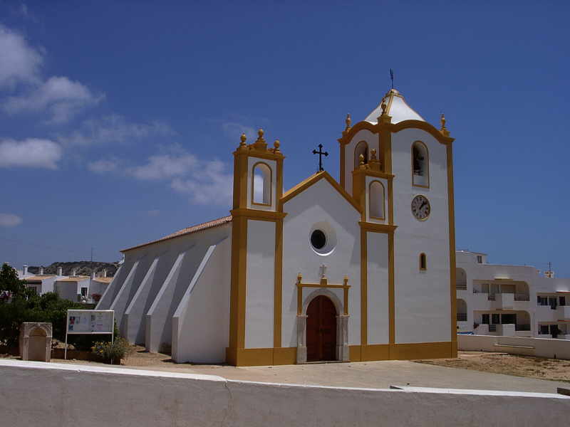 Praia da Luz - Church - ( Igreja )
The Church of Nossa Senhora da Luz ( Our Lady of the Light ). Located in the center of the town. The original church was badly damaged in the earthquake and subsequent tsunamis in 1755, The
fairly plain styled current one was then built with local contributions ( which are still very much welcomed ). It can't be missed as it is yellow and white and beautifully maintained.
 Praia da Luz - Black Rock - ( Rocha Negra )
Wherever you are in Luz you can't miss the Rocha Negra cliff ( a product of the volcanoes of Monchique some 150 million years ago ) that dominates the eastward view. The spectacular lump of
black granite has pushed through the typical Algarve sandstone cliffs, resulting in one of the Western Algarve's most famous sights. If viewing on the map above, switch to the satellite view and zoom
in to more fully appreciate the sight.
Sagres
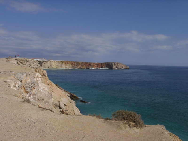 Sagres - Atlantic Coast Views
Sagres is the nearest town but Cape St.Vincent is the actual spot some five minutes further on. Called the 'End of
the world' but actually is the most South-Westerly point of Europe. There is nothing out there until you get to America. Truly a wild spot though catering well for tourists with tourist stalls and
snack bars throughout the summer. The views North and East along the coastlines are fantastic especially on a clear day.
If viewing on the map above, switch to the satellite view and zoom in to more fully appreciate the actual location.
Salema
 Salema - Beach Fossils
Whilst there are several areas of the Algarve that feature fossil remains, probably the most accessible are the ones to be
found on and around the cliffs at the western end of Salema beach. Look carefully around the base of the cliffs, especially at low tide. Dinosaur bones and footprints to be found here. Ammonites for
those who look carefully enough.
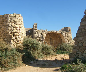
Roman Fort remains.
Other Places
 Forte de Almadena:
The fort was built during the 16th century by King Joao III.
Burgau
Has the remains of 17th century fortifications built during the reign of King Joao IV.
Figueira
Has the remains of a 16th century fortification.
Zavial
Has the remains of a 17th century fortification and the ruins of a large masonry tower, formerly part of a watchtower, can be seen at Ponte da Torre.
Boca do Rio
Has the remains of a Roman villa, bathhouse and fish salting tanks.
 Menhirs ( Standing Stones )
Evidence of the existence of human presence as far back as the Stone Age.
In the Budens area:: Adreneira (3), Vale do Oiro (2), Canimos (3), Figueira (6).
In the Raposeira area: Barreiros, Gasga (6), Milrei (21), Padrao (15), Ingrina(3) and Ladeiras (2).